Building digitalization map for concentrated farming area

The Department of Agriculture and Rural Development has implemented the project to build the digitalization map for concentrated and specialized farming areas to cultivate key and signature products in the northern province of Bac Giang.
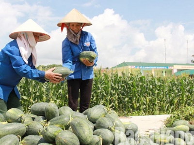
Farmers in Nam village, Dong Viet commune, Yen Dung district harvest watermelon.
Accordingly, the geographic database and digitalization map will be built on the Geographic Information System for the concentrated, specialized and hi-tech farming areas to cultivate key and signature products.
Digitalizing the areas help evaluate the advantages of each land to support the sectors and localities in giving good farming instruction that suits to actual situation. The project is done with the execution cost of over 1.3 billion VND (nearly 56,000 USD) from the provincial budget within 2020.
Now, the province has hundreds of concentrated and specialized farming areas with many signature products which help farmers earn high income. The big concentrated and specialized farming areas are located at the districts of Luc Ngan, Luc Nam, Tan Yen, Yen Dung and Lang Giang.
Related news
Tools

Phối trộn thức ăn chăn nuôi

Pha dung dịch thủy canh

Định mức cho tôm ăn

Phối trộn phân bón NPK

Xác định tỷ lệ tôm sống

Chuyển đổi đơn vị phân bón

Xác định công suất sục khí

Chuyển đổi đơn vị tôm

Tính diện tích nhà kính

Tính thể tích ao


 Central Highlands farmers adapt to climate change
  International pepper conference discusses solutions on sustainable development